Wednesday, October 31, 2012

Happy Halloween!

 
We got the pumpkins out and carved last night in preparation for Halloween night! It is going to be a cold one this year. Take a look at your detailed forecast below.
 
Halloween (Today) we will see partly cloudy skies through out the day. A chilly high of only 48* degrees. An even colder nightly low of only 27* degrees! Get the heavy coats out and dress warm if you're planning on heading out trick or treating this evening. Winds will be light around 10 and 15 mph. A few gusts to 20 mph are likely.
The cold is really trying to set in here in the midwest. How long will it last? Will it get even colder? I will try to have a post on this very soon. Until then, enjoy your night of fright! ;)
 
Here's some funny Halloween scares to help get you in the spirit!

Happy Halloween!

Tuesday, October 30, 2012

"Frankenstorm" A Halloween To Remember! Hurricane Sandy Taking A Toll On The East Coast And Blizzard Conditions On The Western Edge. West Virginia With Over Two Feet Of Snow!

Hurricane Sandy has made an huge impact on the coast and inland as water and wind are not the only major events going on. Blizzard conditions have been pounding areas like West Virginia. This has been a crazy few days for sure in the states!
 
This has been a very dangerous and deadly storm. Already at least 16 dead across the east coast due to this super storm. It's no wonder this storm is nicknamed "The Frankenstorm". Our thoughts and prayers go our to all the families effected by Hurricane Sandy.
 
Here are a few pictures from Sandy below. Taken from the NYC area.
Maria LaRosa uploaded this photo and tweeted, "Part of Atlantic City's boardwalk (built to hold up a firetruck) obliterated!
 
Aubrey Whelan uploaded this photo and tweeted, "Streets flooding pretty extensively outside my hotel in Atlantic City.
 
The river coming up 20th st.
 
Yaron Samid uploaded this photo and tweeted, "Just now outside my window, huge tree branch falls on moving NYC taxi with passengers. Everyone ok.
 
Alex Ogle uploaded this photo and tweeted "Crazy photo -- 20th Street and Avenue C in Manhattan.

That's the wetter side of Hurricane Sandy. Now take a look at the snowy blizzard side of this storm. This is just a few short miles on the western side of Sandy in West Virginia.

The national weather service has reported that a foot and more of snow has fallen in West Virginia. Already 205,000 people without power. Higher elevations in the mountains have seen well over two feet of snow with blizzard warnings in effect in many counties until Wednesday. This is a Halloween that many will never forget.


Here is a raw video above. October 29, 2012 - heavy snow in Davis, West Virginia. Hurricane Sandy slowly moving ashore. Snow on the west side of the storm. Blizzard warnings in effect.
 
Here's a look at the national radar taken at 11:35am EDT. You can see all the dark blues in this image where the blizzard conditions are taking place.
As for us here at home. We still have Wind Advisories in effect until 8:pm EDT this evening. Winds still expected to gust between 35 and 45 mph. Slightly higher gusts possible in open areas. Take it slow on the roads and be careful! We're going to see a low tonight around 32* degrees, so any precipitation to move into the area could very well fall as a mix of rain and snow. However with that said, Any precipitation would be around a tenth inch or less. Most should stay off to our east. As for our Halloween forecast? It's gonna be breezy and cold this year. Take a look.
 Mostly cloudy skies across the area. High only around 48* degrees and a low that night cold at 28* degrees. Again I say a Halloween to remember!
 
Stay warm and safe everyone. I'll check back again soon.

Monday, October 29, 2012

Hurricane Sandy Hitting Hard On The Coast. Today's Peak Gusts Of 38 Mph In The Lafayette, IN Area Only To Get Stronger.

A WIND ADVISORY REMAINS IN EFFECT UNTIL 8 PM EDT TUESDAY.

* WINDS: SUSTAINED NORTH TO NORTHWEST WINDS OF 25 TO 35 MPH WITH
  GUSTS OF 40 TO 50 MPH.

* IMPACTS: DRIVING MAY BE DIFFICULT ESPECIALLY FOR HIGH PROFILE
  VEHICLES. LAWN FURNITURE AND OUTDOOR DECORATIONS MAY BE BLOWN
  AWAY IF NOT SECURED.

PRECAUTIONARY/PREPAREDNESS ACTIONS...

A WIND ADVISORY MEANS THAT WINDS OF 35 MPH ARE EXPECTED. WINDS
THIS STRONG CAN MAKE DRIVING DIFFICULT...ESPECIALLY FOR HIGH
PROFILE VEHICLES. USE EXTRA CAUTION.
~~~~~~~~~~~~~~~~~~~~~~~~~~~~~~~~~~~~~~~~~~
We have already had winds gusting this afternoon near 40 mph in the Lafayette, area. Take a look at today's peak wind gusts.
This is just the start of what we will feel from Hurricane Sandy over the next few days. Tomorrow winds will only get higher as we could see gusts anywhere from 40 to 50 mph across the state!
 
Still what we're going to see from this storm is nothing compared to what the east coast is going to encounter. Heavy rainfall has begun along with the wet heavy snow, high damaging winds, and strong Storm surge. Here's a look at the current radar below.
You can see where that cold air is wrapped up in this storm. 12+ inches of snow is very likely in these areas! anywhere between one and two feet of wet heavy snow is possible.
 
Here is a look at the national weather service 12 inch probability chart below.

You can see in that red shaded area a 70% chance of at least 12" inches of snowfall is likely!
Here are the current expected rainfall totals over the next 1 to 3 days.

Here are a few videos of Hurricane Sandy out of the NYC area. Just listen to the high winds blowing through the state. 


Raw footage: Hurricane Sandy from a tower in Manhattan. Extreme winds, skyscraper swaying, no damage so far...
 
Here's another video of Hurricane Sandy below.

Hurricane Sandy Making Landfall in New York City

Heavy rain, high winds, even heavy snow! How will hurricane Sandy effect us in the hoosier state?

Hurricane Sandy is making headlines this week as it continues to move closer to the coast.  Right now I'm looking for her to make landfall between tomorrow 18Z and 0Z. Basically between tomorrow late into early Tuesday. Take a look at this time range map of Sandy below.
I have never seen a hurricane hit this close to NY before. This thing is a beast! Expected to be a category one hurricane when it hits land. This storm will give way to high damaging winds, heavy heavy rainfall, and even snow in areas. Take a look at hurricane Sandy on satellite image below.
Residents from New England to New York, Pennsylvania, New Jersey, Delaware, Maryland, Virginia, West Virginia and eastern Ohio should be ready to brace for the storm. Tens of millions will feel the effect of hurricane Sandy. The effects will range from widespread wind damage, high storm surge, major flooding, even wet heavy snow in areas depending on your location. Its hard to think of both a hurricane and snow in the same system. However its possible that as much as one to two feet of snow could fall on the western edge of this hurricane as it pulls in a lot of cold air!
Above is a closer local satellite image of Hurricane Sandy. So how will this hurricane effect us in the hoosier state? Well, I'm forecasting a lot of strong winds in our area over the next few days. With peak high wind gusts during Tuesday. Take a look at this map below.
Yes, winds between 25 and 30 mph on Monday gusting between 30 and 38mph at times. Only to get higher as we head into Tuesday. Winds expected to be between 20 and 25 mph gusting between 35 and 40+ mph. some gusts near 50 mph are likely in areas! Yes its gonna be windy and chilly.
 
Here's a look at your detailed forecast below.
 
Today (Monday) we will see partly cloudy to mostly sunny skies across the area with a high around 52* degrees. Winds will be between 10 and 20 mph gusting between 30 and 38 mph possible. Tonight we will see partly cloudy skies with a cool low around 35* degrees.
 
Tuesday- we will see partly cloudy skies to start things, Increasing clouds as the day continues into the evening and overnight hours. Winds will be between 20 and 25 mph gusting anywhere from 35 to 40 mph to possibly 50 mph at times. There is a real slight chance of a stray showers or two however dry for the most part. Any rain would be few and far between if any at all. A low Tuesday night around 32* degrees.
 
Wednesday- (Halloween) we will look for cloudy to partly cloudy skies through out the day. High will be a chilly 46* degrees with a cold low that night around 32* degrees. winds breezy between 15 and 20 mph gusting to 25 mph at times. Looks like we're gonna have to take the coats along trick or treating this year.
I will continue to watch your Halloween outlook as we continue to move closer. That's it for now bloggers. Have a great Monday. God Bless.

Sunday, October 28, 2012

Hurricane Sandy Details Coming Soon.

I'll try to have a post up later tonight talking about Hurricane Sandy. How it will effect NY and the coast. Also how it will have an impact on us here at home.
 
Details to come.

Friday, October 26, 2012

Cold front leads to snow showers. Cold air plunges into the states!

Well bloggers, the cold front has made its way though the area and the cold air has arrived! For now at least. We may not have any snow in the forecast for our area just yet, but take a look at all the snow behind this cold front in the central states.
You can see the line of rain which is a good indicator of where that cold front currently is, and all the blues behind it. Yes some snow showers are even in northern Texas. Look at the current temperature chart below.
Currently 20s and 30s in a good portion of the states. Brrrrrrrr. Winter is coming bloggers! Stay tuned and stay warm.

Thursday, October 25, 2012

Looking Like A Chilly Halloween!

We're tracking another strong cold front to push through the area tonight into tomorrow (Friday). It will again give way to a line of showers / thundershowers across the area. Take a look at this prog chart below.
This is looking into later tonight / early Friday morning. You can see that cold front pushing across the area with the rain forming along the front. Right now I'm looking for rainfall between a tenth and a quarter inch with slightly higher amounts in any thunderstorms.
Here is a look at  the radar image taken at 1:40pm EDT below.
You can already see that line of rain developing on radar. The warm air out in front of this system and the much colder air behind it. Take a look at the snow falling in that colder air just behind the front.
this colder air is what will move into our area as we head into tonight / Friday. Its going to stick around for awhile. Here's a look at your detailed forecast below.
 
TONIGHT- we will look for cloudy skies across the area with that line of showers / thundershowers moving into the area as we head through the evening. Expect a low tonight around 42* degrees with winds between 10 and 15 mph gusting to 20 - 28 mph.
 
FRIDAY- we will start out with a few left over showers / thundershowers possible. However skies will begin to clear out becoming partly cloudy as the day goes on. A high around 52* degrees with a low Friday night around 33* degrees. Winds light between 10 and 15 mph.
 
SATURDAY- we will see mostly sunny skies across the area with a cool high around 52* degrees. winds light and a much cooler low around freezing at 32* degrees.
 
EXTENDED OUTLOOK- Monday through Thursday we will see highs in the 40s! With lows in the lower 30s and upper 20s. Its gonna be chilly! Wednesday (Halloween) is looking good weather - wise. A little chilly with a high around 47* degrees and a low that night as the trick or treaters head out of 30* degrees.
Right now the NAO and AO models are showing another slight warm up before any real hard core cold sets in. You can see the dip in the NAO model below showing the cool down for this week into the first of November. However it's trying to go neutral again as we head into that first week of November.
Here is how the AO model is looking below.
Both showing that spike in temperatures into the first week of November. So cold weather lovers don't get your hopes up yet. This cold burst isn't gonna last to long. We will continue to look ahead and see when we can find a good hard core cold trend set in place.
 
That's it for now bloggers. Have a great day and God Bless!

Tuesday, October 23, 2012

Crazy Rainfall Totals!

We had some really wide spread rainfall totals around the area this morning. Some areas that only saw 0.10" inches while others just a few short miles away saw 1.52" inches! Just amazing. Take a look below.
Areas around Lafayette, and West - Lafayette that were expected to pick up a grand rainfall total of .25" inches ended up with .36" to .60" inches of rain. While areas around Tipton, only saw a tenth inch. Remington, in Jasper county picked up .67" inches as their next door neighbors in Kentland up in Newton county picked up a whopping 1.52" inches! Its just crazy how wide spread these rainfall totals were. It really shows you how much the heavier bands of rain impacted certain areas.

Monday, October 22, 2012

Autumn Fun Facts

Yesterday was a GREAT day weather - wise and otherwise! It was perfect weather for football. My girlfriend took me down to Indianapolis Sunday for the Colts game vs the Cleveland Browns. It was a nice cool 68* degrees and the stadium roof was open. I have never been to Lucas oil stadium before. Let me tell you it is AMAZING! And even better, the Colts won! It was a good close game. Here are a few pictures I took below.
The fireworks as the Indianapolis Colts ran into the stadium.
The humongous American flag that covered the entire football field while they sang the national anthem.
 
Me and my Sam getting ready for the game to kickoff. All decked out in our Indianapolis Colts gear! haha.
And of course the Colts winning the game with a score of 17 to 13. I think these two are my favorite pictures from the game yesterday. I have never seen so much blue in one place. I truly felt at home lol.
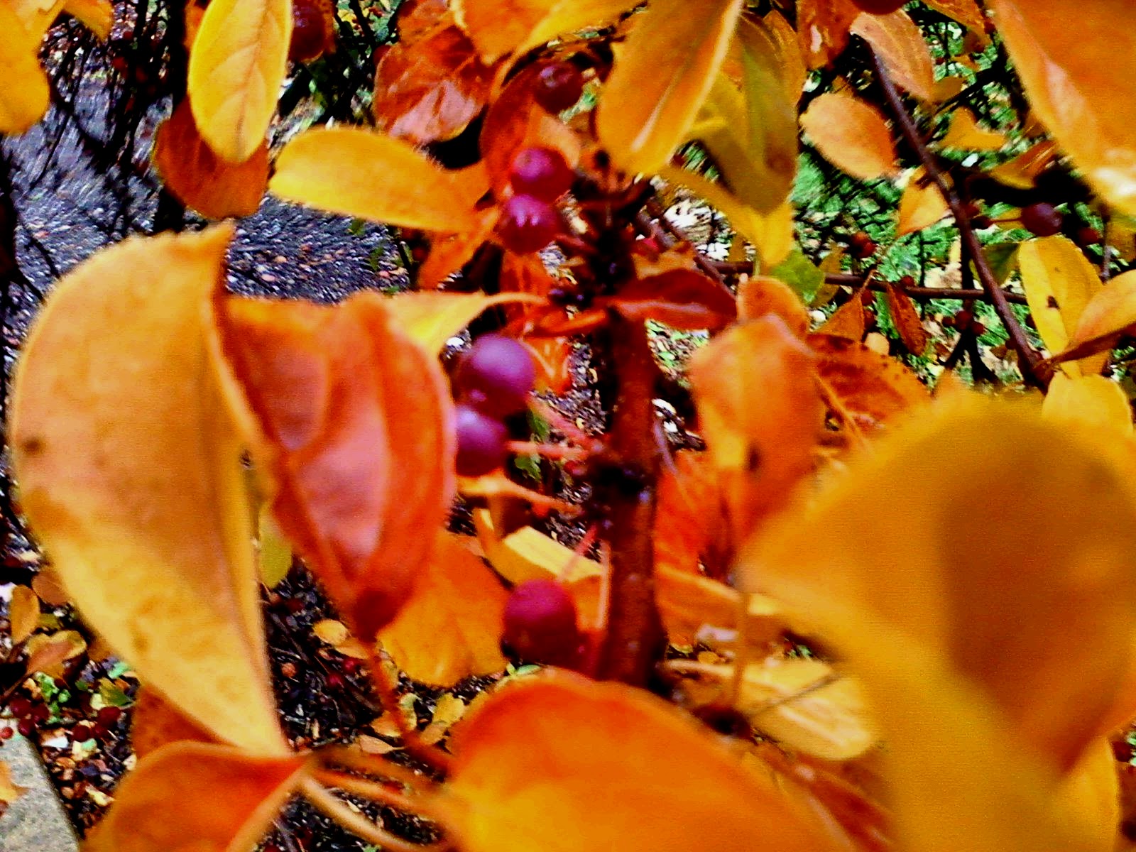
This is definitely something we'll have to do again sometime. Now as we look back into the weather world, lets see what we have in store. First off, have you seen the fall foliage lately? Its beautiful right now. All the trees are getting to that peak color time. I went out just the other day and snapped a few pictures and they turned out great. Take a look below.
A few fun weather facts I found searching the Internet to go along with the pictures. What happens to plants during autumn? Plants and or trees use sunlight to feel themselves. By creating nutrients. This helps them keep their green color during the summer months. As days get colder and days get shorter the plants stop producing these nutrients which is why the leaves start to change colors. Yellow and oranges sit under the green color year around, Reds and browns are from nutrients trapped inside the leaves.
One of the visible signs of fall is the changing color of the leaves. This happens because photosynthesis stops during this period so leaves do not stay green. Evergreen trees remain green through the winter because they have waxy leaves which do not allow them to freeze.
 While we call this season ‘fall’, the British call it ‘autumn’. Both words date from around the same period in the 16th century. Before these terms came into use, this period was called 'harvest'. I have used both Autumn and Fall in this post today. So now I'm curious which term you use! I have added a voting poll on the top right of this page. I will keep it up for around a week or so. Please click what term you use so we can fine out which is the more popular one.
As for your forecast. Lets take a look below.
 
TONIGHT- we can expect partly to mostly cloudy skies across the area. A few light scattered showers will try to move into the area. However rainfall will be around a tenth inch or less. Winds tonight around 10 and 15 mph maybe a few gusts near 20 mph at times. Low around 58* degrees.
 
TUESDAY- we will see a high around 77* degrees with mostly cloudy skies. Another chance for a few light scattered showers in the area. Rainfall around a tenth inch. Winds light between 10 and 15 mph. As we head into Tuesday night I look for mostly cloudy skies with a low around 56* degrees.
 
WEDNESDAY- we will start to clear out once again with partly cloudy skies over the area. A high around 79* degrees likely with a low Wednesday night around 57* degrees.
 
EXTENDED OUTLOOK- We could possibly see highs near that 80* degree mark between Wednesday and Thursday before our big cool down by this weekend. Friday we're watching another line of showers along a cold front to push through the area. As we look towards Friday night and into the weekend we will see lows around freezing once again.
~~~~~~~~~~~~~~~~~~~~~~~~~~~~~~~~~~~~~~~~~~~~~~~
Send me your weather pictures bloggers. Message them to me using the JIWB facebook page at http://www.facebook.com/?ref=home#!/pages/Justins-Indiana-Weather-Blog/194210110637780?fref=ts And also don't forget to vote on your favorite Autumn / Fall / Harvest term in the top right of this page! ;) Take care and God bless.

Friday, October 19, 2012

Looking like a nice weekend for the Colts to take on the Browns

Well, we have been seeing rain for the past two days now all do to this strong low pressure system to move through the area. Here is a look at the rainfall totals from around the area from last night. Take a look.
You can see the farther north you go in the state the higher the rainfall amounts got. Remington, coming in with the higher total last night with .42" inches. Attica, with .28" inches and bringing up the rear is Frankfort, with .13" inches of rainfall. It seem like nature is trying to catch up on all that missed summer rain.
 
We will continue to see mostly cloudy skies in the midwest today with a few more off and on showers in the area. We still have that low pressure over our heads at this time. You can see in this radar image below taken at 3:17pm EDT. We're catching that back side of the low pressure system right now with the light scattered showers.
Eventually this system will push off to our east. We may still see a few hit and miss spotty showers in the real early morning however I think we will start to dry out as we look towards Saturday.
 
Sunday is also looking like a great day weather-wise. Take a look at the football forecast for the area below.
That's right I'm calling for partly cloudy to mostly sunny skies across the state with a mild high around 67* degrees. Winds will be light between 10 and 15 mph. Expect a low Sunday around 50* degrees. I'm hoping for a good day for the Indianapolis Colts as they take on the Browns. I'll be at the game with my girlfriend. I'll be sure to take pictures and hopefully come back with a win!
 
Take care bloggers. I'll check back soon.
God Bless!

Thursday, October 18, 2012

Strong low pressure system looks like a hurricane on land!

The second half of this system has been moving through the area this evening and will continue to make its way through the midwest as we continue through Friday. It will be a wet and chilly day. Take a look at how amazing this system looks on satellite below.
This thing really does look like a hurricane on land with how strong the low pressure is spinning. I have been waiting to see this thing live ever sense I started forecasting it with the weather models. We have had some gusty winds with this system as forecasted. Take a look at the peak wind gusts from around the area yesterday. (10-17-12).
39mph peak wind gust in the Lafayette, area. 38mph wind gust in Indianapolis. 38mph gust in the Monticello, area. and 36mph gust coming out of Kokomo.

Here is another look at those final rainfall totals from around the area from yesterday as well. I will have new rainfall totals up from tonight's rain by tomorrow morning / early afternoon.
I'll check back soon.

Autumn Rain.

Here's a quick look at the final rainfall totals from around the area last night. I will be back later this evening with a look at the peak wind gusts and anymore rain totals from this afternoon. Stay tuned!

Wednesday, October 17, 2012

Watching This System Develop.

You can see this system starting to develop on radar. I'm expecting it to move into the area later on this evening into Thursday. Heavy rain bands and windy conditions will be our main threats with this system. You can see where we stand currently in this radar image below.
Radar Image Taken At 9:21pm EDT..
 
You can see the line of rain forming along that cold front in this image above. Right now I'm still looking for rainfall between .50" inches and 1.50" inches. Expect slightly higher amounts in any thunderstorms.
This model image above is looking into later this evening / early early Thursday AM. 6Z time.
Get your rain gauges out and ready bloggers. I'll be at work but I'll check back soon.

Tuesday, October 16, 2012

Incredible looking system. What Wednesday and Thursday have in store for the midwest.

Its been great fall weather the past few days. However all that is about to change. We are watching another developing system coming from our west that will give way to more wet and windy conditions across the midwest. You can already see our Wednesday system developing on radar. Take a look at this radar and surface image below.
All that rain on radar you see in the left yellow box is whats developing for Wednesday into Thursday. You can also see the cold front that will define this system in the surface chart to the right. This is a strong low pressure system. Much like earlier in the week when we saw 44mph wind gusts in Lafayette, this will be another high gusty wind event!
 
Here's the break down on how this system currently looks to play out over Wednesday afternoon into Thursday.
Starting out with scattered rain showers across the area Wednesday afternoon we will see that cold front near the area.
As we head into later Wednesday evening / night we will see the much heavier bands of rain move through the area. As you can see in this model above. We're expecting rainfall between .50" inches and 1.50" inches. Maybe even slightly higher amounts in areas that see thunderstorms.We could see winds blowing between 10 and 20 mph gusting between 25 and 38 mph at times. Though I don't see anything severe in this system for our area. Gusty winds and heavy rain seem to be the main threat.
We will see a slight break in the rain and clouds as we form a dry slot in this system later on Thursday morning / early afternoon before that second half of the system catches us. You can see the dry slot in this model image above.
Thursday evening the clouds roll back into the area bringing whats left of the system. Scattered showers and a few gusty winds to 25 mph likely. Much cooler air will be in place Thursday and Friday after that cold front pushes through. Highs only in the 50s! As few spotty showers will linger into Friday off and on through out the day.
 
This storm almost looks like a hurricane on land. Its so big, it really is incredible looking!
Here's your forecast below.
WEDNESDAY- We will start out with partly cloudy skies across the area. Clouds and rain will move in as we head into the afternoon hours. Expect a high around 73* degrees with winds between 10 and 20 mph.
 
WEDNESDAY NIGHT- We will see rainy and windy conditions across the state. Rain will be heavy at times along with winds gusting to 25 and 38 mph. Look for a low around 42* degrees. Rainfall between .50" and .75" inches.
 
THURSDAY- We will see rain showers in the early early morning. However that will try to tapper off as we hit late morning. We will form a dry slot in this system giving way to partly cloudy skies during the afternoon hours. The second round of scattered showers will move into the area later on in the afternoon / early evening. Look for a chilly high around 59 * degrees and a low around 43* degrees. Winds between 10 and 15 mph gusting to 20 and 25 mph at times. Total rainfall between Wednesday and Thursday is looking between .50" and 1.50" inches. Slightly higher amounts in any thunderstorms.
 
EXTENDED OUTLOOK- Still some lingering spotty showers as we head into Friday. Otherwise mostly cloudy skies across the area. Friday will be another chilly day with a high in the lower to middle 50s. 50s and 60s will be our high as we finish off the work week. Clearing skies near the weekend!