Friday, June 24, 2011

80s Return With Clearing Skies To Kick Off The Weekend!!

Yes, you can see above in this satellite image I took just after 5:30pm EDT this evening, the clouds will soon be moving away and the sun will move back into the area in time to kick off the weekend! Finally our fair weather friend Mr, High pressure will pay us a visit! It seems we have been tracking that low pressure system you see above forever! lol. But finally some sun is on the way.

Take a look at Saturday's forecast below.
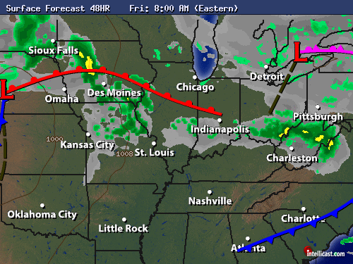
This is a surface chart looking into Saturday morning around 8:am EDT. You can see that high pressure will try and move into the area clearing skies through out the day. Yes, I'm looking for partly cloudy skies across the area to start the weekend. We will see a few clouds move back in by Saturday night with rain back by Sunday however Saturday is looking great at this time! Not only with partly cloudy skies but also awesome temperatures!
Yes, the temperature forecast for tomorrow (Saturday) is all about how the 80s return! Can you believe that I recorded a high in the Lafayette, area today of only 67* degrees! WOW. That's a good 13* degrees below our average high for this time of year. I know the calender says it's officially Summer however it hasn't felt it since it's officially started lol. However that will soon change as I see possible 90s returning by the start of the work week. So hang in there warm weather lovers.

Here's a look at your quick cast below.

Weekend Quick Cast.....

Saturday we will look nice with partly cloudy skies across the area. Highs in the lower 80s around 82* degrees with a low back up into the 60s around 64* degrees. Winds light between 3 and 5 mph. We will see more clouds move back into the area later on that night however during the daytime hours things are looking great to start the weekend!

Sunday we will look for mostly cloudy skies with a chance for some more rain showers in the area. A few thunder rumbles / thundershowers are possible. Expect a high Sunday in the lower to middle 80s around 84* degrees, and a low that night in the 70s around 72* degrees. Winds between 10 and 15 mph with a few gusts near 20 mph possible at times.
~~~~~~~~~~~~~~~~~~~~~~~~~~~~~~~~~~~~~
~~~~~~~~~~~~~~~~~~~~~~~~~~~~~~~~~~~~~~~~~~

So have a great weekend bloggers! I'll check back again soon.

Take care and as always God Bless!

Wednesday, June 22, 2011

River Update. Also Cooler And Cloudy Is Forecast Over The Next Few Days.

Well, first off lets go ahead and get everyone up to date on the rivers! You can see in the image above all the river details. We have had continued lowland flooding in much of the state over the last few days. Good news is I'm not seeing anymore heavy rainfall in the forecast for a little bit! Which means we will start to see some of the rivers go down overtime. So this means that much of the flooding in central Indiana should end by this weekend.

However flooding along portions of the Wabash river may extend into early July! So if you live by the rivers, this is something to take note of.

So again the good news is I'm not seeing anymore heavy heavy rainfall to move into the area over the next few days. Take a look at what tomorrow's surface chart looks like below.
That's right. Cooler and cloudy is the forecast at this time. As you can see I'm going to go ahead and keep a real slight chance of a stray small brief showers in the viewing area possible. However this is s slim chance! Otherwise mostly cloudy skies and highs in the 70s around 74* degrees. So why are we so much cooler for the rest of this week??

Take a look.
Above is a look at what today's surface chart looked like earlier this afternoon around 2:00pm EDT. You can see we have been watching a passing cold front move across the area. And it's bringing some cooler air with it from the northwest. Also the cloud cover over the next few days thanks to a strong low pressure system to our northwest will also help to block the sun and keep us with highs in the 70s.
You can see the low pressure I'm talking about in this satellite image above taken at 5:18pm EDT this evening. This is moving east keeping us cloudy over the next few days. A few brief breaks in the clouds from time to time possible however I'm not seeing 80s as we head into Friday.

80s will return by this weekend with possible 90s or at least near 90s by the start of next week. Here's your weather break down below.

Quick Cast.....

Thursday we will look for mostly cloudy skies across the area. I cannot totally rule out the slight chance of a brief stray shower somewhere in the WLFI viewing area. However overall we will see mostly cloudy skies. Expect a high around 74* degrees with a low that night around 56* degrees. Winds between 10 and 15 mph, Gusts to 18 - 20 mph possible.

Friday we will look for mostly cloudy skies to partly cloudy skies possible. Again a slight chance for a brief stray shower is possible. Expect another high in the 70s around 74* degrees with a low that night around 57* degrees. Winds light between 5 and 10 mph with a few gusts to 15 mph possible.
~~~~~~~~~~~~~~~~~~~~~~~~~~~~~
~~~~~~~~~~~~~~~~~~~~~~~~~~~~~~~~~~~

Take care bloggers.
God Bless!

Monday, June 20, 2011

Kicking Off The First Day Of Summer With Highs In The Upper 80s / Low 90s Possible.

Well, it was a busy morning for sure with lots of thunderstorms rolling across the state. Loud thunder and frequent lightning along with heavy heavy rainfall was the story all across the area. We even had a few severe thunderstorm warnings issued in the viewing area. You can see one of them that was issued earlier this morning sometime around 9:am EDT. The main threat with these storms was the heavy rainfall, frequent lightning, and hail! However the only hail report I received nearest to the area was out of Indianapolis with 1" inch sized hail.

The main things we seen in the Lafayette, area was the heavy rainfall and lowland flooding!
You can see above the smaller cells that packed a real punch when it came to rainfall. The darker reds indicate the heavier rain bands. I recorded 3.20" inches of rainfall after the storms passed the area here in Lafayette. A big 2.31" inches recorded in Lebanon.

Take a look at this video I took during the passing of that cell you see above in the Lafayette, area earlier this morning.
You can see what I'm talking about when I say lowland flooding. Flood warnings are still in effect do to lowland flooding in areas. Along with creeks flooding over and some rivers near flood stage after this event. This is something we will be watching overtime.

So now the question is, "Do we have more rain on the way?". Well, we have another chance for scattered hit and miss pop up showers / T-storms as we head into Tuesday.
This surface chart above is looking into 2:pm EDT Tuesday. You can see all the possible scattered pop up showers / T-storms in the area. So we will be watching things off and on through out the day tomorrow as well. Otherwise partly cloudy skies!

And last but not least! I know it has felt like summer for a while now however the first official day of Summer gets kicked off tomorrow!
Yes, summer begins tomorrow at 1:16pm EDT. And if we see more sun then clouds tomorrow we could be pushing the low 90s to start off the first day of summer. It will be close!

So have a great first day of summer everyone.
As always, Take care and God Bless!

Tonight's Topic.

Be ready bloggers because tonight we're gonna be talking about the minor flooding that is and or has occurred during this past storm system to push through the area. Also the start of summer coming in with low 90s likely!

Be sure to check back.

Rounds Of Storms!

The first wave of thunderstorms you see to the right of this image is starting to pass through the area. Western parts of the viewing area are looking much better at this time! The second round is to the left of this image still in areas of ILL, This will try to move east and may clip some of the northern viewing area counties. Otherwise we will look okay for a while, Still the chance for a few more pop up scattered showers / T-Storms later on this evening...

Once things start to heat up again I will be back with updates!
Above you can see where that severe warned cell is inside the red box, This cell is moving southeast. Just take a look at the hail core inside this storm below.
This is the main reason for the severe thunderstorm being issued in this area! Main threats if your in or around this cell will be quarter sized hail, heavy rainfall, and dangerous lightning.
...THE SEVERE THUNDERSTORM WARNING FOR EASTERN FOUNTAIN COUNTY IS

CANCELLED...
I was expecting this severe thunderstorm warning to be issued soon after my last post. This cell could give way to quarter sized hail, and brief heavy down pours! Also winds up to 45 mph are likely!

* SEVERE THUNDERSTORM WARNING FOR...

EASTERN FOUNTAIN COUNTY IN WEST CENTRAL INDIANA...

MONTGOMERY COUNTY IN WEST CENTRAL INDIANA...

SOUTHERN TIPPECANOE COUNTY IN WEST CENTRAL INDIANA...


* UNTIL 1000 AM EDT


T - Storm Update.

Above is a look at the latest radar image. Good news is currently none of these cells have severe thunderstorm warnings with them! However there are some embedded mesocyclones inside them, Which means that they have the potential to rotate however are not currently! The mesocyclones are showing up by the circle icon just southwest of Lafayette, Also some small hail is possible in the darker reds just southwest of the Lafayette area, Things will continue to be laoud and wet over the next hour or so for the Lafayette, area and over the next few hours the more west of Lafayette, you go.

So again currently nothing warned which is good news, If anything changes I will let you know!

Sunday, June 19, 2011

90s Return!

Well, my grandma had a great birthday. She even went on a moped ride that evening lol. For those of you who don't know my grandma, She loves to ride her moped! lol. 65 and still as wild and fun as ever lol. That's that Hatke spunk lol :)

Well, bloggers the past few days we have seen that the forecast has been calling for scattered thunderstorms just about everyday this past week. However we have seen more partly cloudy skies then anything! So whats the deal?? Well, when the forecast says Chance of scattered pop up showers or thundershowers in the area, it's just that! A Chance!. Otherwise we have been looking for partly cloudy skies. This is the pattern that will continue into the next few days as well. Take a look below.
This chart above is looking at tomorrow morning (Monday at 8:am EDT). You can see we are looking for a chance of a few scattered hit and miss showers / thundershowers in the area. Some of the storms that pop up could become strong at times in parts of the WLFI viewing area. Because of this chance for some pop up strong storms somewhere in the WLFI viewing area, the national weather service has gone ahead and issued our area to be in that slight risk for severe.
You can see us in that yellow area above. Now again I want to point out that not necessarily everyone in the viewing area will see storms, or strong storms for that matter. We have around a 40% chance of scattered showers / T - storms in the area. Otherwise I look for partly cloudy skies.

This is much of the same story for Tuesday as well. A chance of scattered pop up showers / T - Storms in the area, Otherwise partly cloudy skies.
The big difference on Tuesday will be the temperatures! Yes, you can see that warm front moving through the area Monday night bringing the low 90s as high by Tuesday! (POOL WEATHER) ;)

Just remember to be safe!

That's the break down on this weeks odd forecasting weather. I'll be here if needed. As in if we do happen to see any stronger storms move into the area!

Take care and God Bless!

Saturday, June 18, 2011

Updates On The Way

Hey bloggers. I know you are ready for my posts to get back into high gear lol. And I will do my best to post more often! ;) still today I have a busy day however I will try to be back here with a new post by Sunday. Then I hope to start getting back on track with more frequent updates. Today is my Grandmas 65th birthday!! Yes, Maxing Hatke New, is 65 today!!! WOOOOOHOOOOOO :)

Happy birthday grandma! I have a cookout planed and an afternoon filled with family time.

Then if the weather holds I have a softball game around 5:pm. So a busy day today however I will try to be back with updates by Sunday night!

Take care bloggers!

God Bless.

Wednesday, June 15, 2011

Outlook Into The Weekend.

Hey bloggers. Sorry I haven't posted in a while, Things are starting to get busy with it being summer and all. So I thought I'd pop in with a quick look at your forecast over the next two days. Hows that sound?

Let's get right to it.

Quick Cast.....
Above is a look at the surface chart for tomorrow (Thursday). I'm keeping around a 30% chance of a few hit and miss scattered showers / thundershowers in the area. However this is a slight chance. Some areas of the viewing area could see showers while others may stay dry. Otherwise I look for partly cloudy skies across the area. Highs in the lower 80s with a low that night in the lower 60s. Winds between 10 and 15 mph.
As we head into Friday, You can see this surface chart above looking at Friday around 8:am EDT. More scattered shower / scattered thundershower chances in the area. Again only around a 30% chance. Otherwise expect partly cloudy skies. High in the middle 80s and a low that night in the lower 60s. Winds between 5 and 10 mph.

As for your extended outlook into Sunday.
Yes, we will be keeping the chance of showers / thundershowers in the forecast all the way through the weekend. But do remember that this is not an all day rain event on any of these days, So don't cancel any plans, Just remember to take an umbrella! ;) Also I see the 90s making a return by this wekend!

Take care bloggers. I'll try to pop in a bit more often!

God Bless.

Friday, June 3, 2011

Pray For No Rain Til After The Game!!

Above is a look at what the surface chart should look like by 8:pm EDT tonight. You can see that warm front is bringing in the warmer air for tomorrow the start of the weekend. I'm talking about highs around 93* degrees. And once that cold front moves in from our northwest we could see a few pop up scattered thunderstorms in the area. Some of which may be severe!
Here is a look at the surface chart for 8:am EDT Saturday. The warm front is passing through and the cold front to the west isn't far away. As we head through out the day tomorrow we have around a 30% to 40% chance of a few scattered hit and miss pop up thunderstorms in the area. Once they pop up we will have to watch them as some could become severe.
The greatest chance for severe will most likely come later on that evening into the early night. You can see above this is a look at the surface chart by 8:pm EDT Saturday. As the cold front moves in more storms will start to pop.

I really hope we miss out on the pop up storms tomorrow as I have a Softball game scheduled for 5:pm that evening. I'm going ahead and telling you all this so that if you don't see me on the blog then you know why!

So pray for no rain til after the game! ;)

Take care bloggers and keep your eyes on the radars!

God Bless!