

And this is not at all it we are still watching more heavy bands forming to our south and west which is moving our way here before long. We are currently thinking closer to 10:pm or 11:pm. This heavy bands will lessen visibility and make driving hard if you can stay home that would be best! We are also seeing a lot of blowing and drifting snow not only here in Lafayette but more in Remington. Or Jasper county. Even though our winds are between 5 and 10 mph with gusts to 15 mph we have a fluffy light snow and it is just blowing it all over. Please take you time and be careful if needed to go out.
Below is the rest of my forecasted amounts for tonight into tomorrow morning and afternoon. I'M currently looking for this snow to start to tapper off between 10: am and 1:pm Wednesday! We will time that out also as we get closer! We will see our winds get a little stronger tomorrow as well and we will keep you posted. Again I still like our 5" to 8" for Lafayette and areas around and here is you map below.......... I will see you again soon..........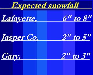
No comments:
Post a Comment