
Quick Cast.............................................
Today. Highs will be warmer in the low 40s! With Partly cloudy skies as a high pressure will move into our area! Winds will be breezy between 20 and 25mph gusts to 30mph are possible.
Tonight. Cool with lows in the mid 20s and Mostly clear to Partly cloudy skies.Breezy Winds between 20 and 28 mph.
Sunday. Highs in the upper 40s to low 50s. Few rain showers off and on through out the day. The good thing is it should not be an all day rain. Windy..... Winds between 25 and 30 mph with possible wind gusts near 40 mph at times.
Extended Outlook. Monday we have another rain to snow system in out forecast however I'M not looking for much sticking snow this time around looking like Less then an inch possible.We will start to fall in temperatures from a highs in the 40s to highs in the 20s on Tuesday! With another chance of a few flurries on Wednesday! So a wild start to the work week but not before you can enjoy a nice looking weekend!
Hey there. We have a wild ride ahead of us for the start of the work week! But first we have a nice start to the weekend!!
 We will have a small warm front that will rise our temperatures today along with our good friend Mr High pressure!! It should be a SUNNY SATURDAY! You should get out and enjoy it while you can if you like mild temperatures. We will be near 50 on Sunday! With a few off and on rain showers possible! The good thing is it is not looking like an all day rain and not looking for any big rainfall.
 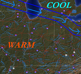 This is the jet stream for Sunday. You see we will be in that warm pocket of air then later that night our temperatures will start to fall as we work our way to the cooler side!! Now why do we need to watch this for freezing rain? Well the jet stream looks to be staying in this pattern! And by that I mean moving up and down. As it moves up and down putting us on the cooler side as these rain then to snow systems move in the precipitation can fall as freezing rain! Though I don't see much in the way of freezing rain this Monday! We will have to watch this later on in the week!
This also puts us on a roller coaster ride of temperatures! We had a high temperature yesterday of 25* Degrees and today we will be around 41* degrees only to be near 50 on Sunday. Then we will start to fall again to the 30s and 20s by Tuesday and Wednesday! We will just have to stick with it till we can start to calm down! :)
Now how about Christmas?????
 That's right I'M currently watching two systems between the 21st and the 24th. Now nothing is set in stone at this time but I will keep a close watch on our Christmas outlook and I will keep you posted! As of right now we do have more then a 50 50 % chance of a white Christmas! So get out the Christmas music which I have already done! :) and Let it Snow Let it Snow Let it Snow!!!!! I will keep you posted on Monday and I will see you soon! Have a GREAT Weekend!!!!!
 Thank you For Reading!!!!! Here is your snowy picture.
This is what I do a lot LOL :) Have a great Weekend Bloggers I will check back soon.....
No comments:
Post a Comment